The Complexo do Pantanal, or simply Pantanal is a biome consisting mainly of a savanna steppe, flooded for the most part, with 250 sq km in length, average elevation of 100 meters, located in southern Mato Grosso and northwestern Mato Grosso South, both states of Brazil, and also encompass the northern Paraguay and eastern Bolivia (which is called the Bolivian Chaco), considered by UNESCO World Natural Heritage and Biosphere Reserve, located in the Pantanal National Park. Despite the name, there are a few in the Pantanal wetlands. Moreover, it has few mountains which makes the flooding.
Divisions
The complex name comes from the region have more than one Pantanal in them (7 in total), and divide into two regions:
Beginnings
The origin of the Pantanal is the result of the separation of the ocean millions of years. Animals that are present in the sea also exist in the marsh, forming what might be called an inland sea. The area flooded wetland is due to slow drainage of water flowing slowly through the region of the Middle Paraguay, in a place called the closing of the South Hills Attracted by the presence of precious metals and stones (which were used by Indians, who already populated the region, such as ornaments), among them the gold. The Portuguese Aleixo Garcia in 1524, became the first to visit the territory, which came through the Paraguay River Miranda, reaching the area where now stands the city of Corumbá. In the years 1537 and 1538, the Spanish Juan and his companion Ayolas Domingos Martinez de Irala followed by the Paraguay River and named Puerto de los Reyes to Gayva pond. Around 1542-1543, Alvaro Nunez Cabeza de Vaca (Spanish adventurer and) also came by to go to Peru. Between 1878 and 1930, the city of Corumbá (located inside the Pantanal) becomes the main commercial axis of the river and the old state Mato Grosso, Mato Grosso do Sul today, then loses its importance for the cities of Cuiabá and Campo Grande thus began a period of economic decline.
The incentive provided by governments from the 1960s to develop the Midwest region through the implementation of agricultural projects has brought many changes in the environments of the savanna, threatening their biodiversity. Concerned with the conservation of the Pantanal, Embrapa installed in 1975 in Corumba, a research unit for the region, in order to adapt, develop and transfer technologies for the sustainable use of natural resources. The research began with the cattle, the main economic activity, and today, besides cattle, covers several areas such as plant resources, fisheries, wildlife, water, climate, soil, assessment of impacts caused by human activities and socio- economy. Recent years have seen massive investments in the sector of ecotourism, with several inns pantaneiras practicing this form of sustainable tourism.
General
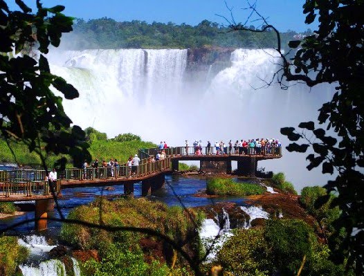
The Pantanal is one of the largest extensions (dry) solid planet and is located in the center of South America in the Upper Paraguay River Basin. Its area is 1.0 square kilometers, with 65% of its territory in the state of Mato Grosso do Sul and 35% in Mato Grosso. The region is a lowland rain affected by rivers that drain the basin of the Upper Paraguay, where he developed a fauna and flora of rare beauty and abundance, influenced by four biomes: Amazon, Cerrado, Chaco and Atlantic Forest.
The Paraguay River and its tributaries run through the marsh, forming extensive wetlands that serve as shelter for many fish, such as painted, gold, pacu, and also other animals such as alligators, capybaras and otters, among other species . Many endangered animals in other parts of Brazil still have vigorous populations in the Pantanal region, as the swamp deer, capybara, caiman and the Jabiru.
Due to the low slope of this plain in a north-south and east-west, the water that falls in the headwaters of the Paraguay River, will spend four months or more to cross the entire Pantanal. Ecosystems are characterized by savannas and cerradões without periodic flooding, floodplains and aquatic environments such as freshwater ponds or brackish water, rivers, streams and low water.
The climate is hot and humid in summer, and although it is relatively cooler in the winter, continues to show great air moisture due to evapotranspiration associated with accumulated water in the soil horizon in the roots during the flood period. Most of the Pantanal soil is sandy and supports native pastures used by native herbivores and the cattle, introduced by settlers in the region. A small portion of the original grassland has been replaced by exotic forage species such as Brachiaria (4.5% in 2006). The surface energy balance (ie, the energy exchange between the surface and atmosphere) is very much influenced by the presence of layers of water that partially cover the ground every summer, and the special characteristics of water and energy balances ultimately influence the development of regional atmospheric boundary layer.
The plain of the Pantanal has approximately 230,000 km ², as estimated by scholars that explain what can hardly be established an exact calculation of its dimensions, for at several points to be very difficult to establish where it begins and ends the Pantanal and the regions that surround it, beyond the closing of each cycle of seasons of drought and water Pantanal changes.
Its area is 124.457.145.22 km ² (64.64% in Mato Grosso do Sul and Mato Grosso in 35.36%. Considered one of the largest sedimentary plains of the planet, the Pantanal is extended by Bolivia and Paraguay, countries where receives other names, and Chaco the best known.
Its constitution, only the planet, is the result of the separation of the ocean millions of years ago, forming what might be called an inland sea. The plain is gently undulating, punctuated by rare isolated elevations, often called mountains and hills, and rich in shallow depressions. Its boundaries are marked by different systems increases as plains, mountains and massive, and is cut by a large number of rivers of different sizes, all belonging to the Paraguay River Basin - the main rivers are the Cuiaba Piquiri, St. Lawrence, Taquari , Aquidauana, Miranda and Apa. The Pantanal is bounded on the Brazilian side (north, east and southeast) of land in altitude between 600 and 700 meters, extends west to the foothills of the Andes and extends south central plains Pampa.
The Pantanal lives under the design of water: there, the rain divides life into two very different periods. During the months of drought - from May to October or so - the landscape undergoes radical changes: the decline of water, fields are discovered, sandbars, islands and rivers resume their natural beds, but not always following the course of the period earlier. The water flowing by depressions in the ground, forming streams (channels that connect the waters of bays, lagoons, wetlands etc.. With rivers nearby).
In large fields covered mainly by grasses and savannah vegetation, surface water gets scarce, restricted to the perennial rivers, with bed set, large lakes near these rivers, called bays, and some smaller ponds and swamps in lower areas of the plain. In many places, it becomes necessary to use ground water, groundwater or aquifers, are using hand pumps and or played with wind mills to guarantee supplies to homes and watering of domestic animals.
The first rains of the season fall on a soil dry and porous and are easily absorbed. From November to April the torrential rains fall in the headwaters of the Paraguay River Basin in the north. With the constant wetting of the land, the plain soon becomes green due to the regrowth of many species resistant to water shortages in previous months. This large increase in periodic water mains in the Pantanal, the low slope of the plain and the difficulty of disposal of water by flooding, are responsible for flooding in low areas, forming bays of hundreds of square kilometers, giving the region an aspect the vast inland sea.
The downpour elevates the level of permanent bays, creates other, overflowing rivers and flooded fields in the vicinity, and isolated hills stand out as true islands covered with vegetation - groupings of these islands are called the Wetland ridges - ridges on the islands and the animals refuge seeking shelter from the rising waters.
At that time it becomes difficult to travel to the Pantanal because many roads are flooded and impassable. The transport of people, animals and goods can only be done on the backs of pack animals and boats - many farms and settlements (also known as corrutela) located in low areas are isolated from supply centers and access to them, often can only be done by boat or plane.
With the rising waters, large amounts of organic matter is carried by the current and carried considerable distances. Represented mainly by masses of floating vegetation and marginal and dead animals in the flood, these remnants, during ebb tide, are deposited on the banks and shores of rivers, lakes and wetlands and, after rapid decomposition, they form the fertilizing element of soil, capable of the enormous diversity of vegetation types existing there.
Among the varied vegetation are countless species of animals adapted to that region of such contradictory aspects. This immense variety of life, expressed in constant motion of shapes, colors and sounds is one of the most beautiful spectacles on Earth. Because of this alternation between dry and wet periods, the Pantanal landscape is never the same, changing every year: the riverbeds change their routes, the large bays alter their designs.
Costumes Pantaneiros
Food
The Pantanal has the habit of waking up too early, the read of his business, for example: a read of their animals in the great plains of the region. In his morning feed, then in the morning before going to read, has a habit of eating very well. This habit is called the break-bent, which is practically a strengthened coffee, bread, rice with dried beef, coffee and other treats offered by the vast plain.
The Tereré
Guarani tradition inherited from the Tereré is a drink served in gourd with yerba mate and water ice. It is quite consumed by the wetland, mainly before noon, after the completion of morning work. It also takes tereré the afternoon and night before, often in conversations among families wheels, pedestrians or friends. This custom has also arrived in the cities of the Pantanal, where people gather on the sidewalks for a "talk for nothing" and refresh themselves with drink. In other regions, as in the West of Paraná, he is filled with soda, but the original tereré composed only of yerba mate and natural water. In the northern region of Mato Grosso do Sul tereré aims to rescue legends, myths, regional music in the wheels of tereré.
Sarrabulho
The sarrabulho is a unanimity in Corumba is a high-calorie dish that few know how to prepare. The dish is of Portuguese origin and became popular in the Northeast and also in Corumbá. In northern Portugal is prepared with pieces of pork or lamb. Here, perhaps for the livestock industry and plenty of product, became the choice for beef cattle, should be served with white rice and boiled cassava. Ingredients for preparation: liver, kidneys, heart, and ground beef.
Achiote
Annatto is a reddish seed, which comes from the Tupi-uru ku, meaning red, popularly known as Annatto, saffron, paprika, scientific name of the botanical family Bixáceas serves as a spice and food coloring. It is widely used in culinary preparations in Pantanal fish, alligators and piranha, the Indians always used to paint the body in their festive celebrations and with it, defending yourself against mosquito bites.
Alligators
Alligators are reptiles well adapted to the environment and still dominate many habitats. Contrary to what you think the alligator is not slow, if it is threatened or is about to pounce, acquires impressive speed. Inside the water, his attack is usually fatal, since it is an excellent swimmer. Alligators are different from the Pantanal of the Amazon. The Pantanal is measuring up to 2.5 m and feeds on fish and is virtually harmless to humans. While Amazon is a little higher (almost 6 feet) and attack when threatened. Its meat is edible, the most noble animal's body that is exploited is the tail. It is a white meat and consistent. Closely resembles the chicken, but has a mild taste of beef and freshwater fish. It can be served fried or stewed like fish.
Piranha Pantaneiro
Piranhas are a group of carnivorous fish that inhabit freshwater marsh, and some rivers in other Brazilian regions, there are three species of piranha in the Pantanal and they can be dangerous. So in place is usually clean fish is not advisable to dive, because it can bite you by mistake. The piranha can also bite after death. Their sharp teeth can cut flesh and bone until a sudden movement. In the Pantanal region their meat is used to make the famous Piranha Broth. How to prepare the broth: Clean the piranhas, let the head and season with lemon, onion, garlic, green smell, salt and pepper. Let stand for one hour. Heat oil and fry for a few minutes piranhas with all the seasonings, add the peppers and tomatoes, add the tomato paste and water, cover pot and simmer. After an hour make sure the seasoning is good. Strain into a coarse sieve and serve.
Economic activities
The main economic activities are linked to the Pantanal, cattle, which is facilitated by the natural grassland and the lightly salted water in the region, ideal for those animals. For pedestrians, farmers and Lontra, the horse is one of the main means of transport. The fishermen, who seek the rivers their source of livelihood and nutrition. There is also a small indigenous population riverside.
Among the environmental problems of the Pantanal are the ecological imbalance caused by extensive cattle farming, deforestation for charcoal production with destruction of native vegetation, fishing and hunting many species of predatory fish and the alligator, the mining of gold and precious stones, which causes erosion, siltation and pollution of the rivers Paraguay and São Lourenço, uncontrolled tourism that produces waste, and sewage that threatens the peace of the animals, etc..
A relatively new activity is eco-tourism, there are already several lodges pantaneiras practicing this form of sustainable tourism.
Corumbá in the steel and mining activity are important generators of employment and income, the environmental impacts of these activities are being evaluated there is much controversy.
The incentive provided by governments from the 1960s to develop the Midwest region through the implementation of agricultural projects, has brought many changes in the environments of the savanna threatening their biodiversity.
Embrapa Pantanal has been developing sustainable technologies for the region.
Hydropower
According to data from Embrapa Pantanal, the installation of 116 small hydropower (SHP) in the Upper Paraguay, largely responsible for the periodic flooding of the Pantanal, threaten fishing, farming, cattle ranching and tourism fishing, especially because 70% will be concentrated in the same region . The dams prevent fish ascend rivers and the transit of nutrients occurs. Consequently, there is the impact on spawning and feeding fish. Another immediate consequence is the increase in siltation, already apparent in Taquari.
Diversity
Flora
The wetland vegetation is a mosaic of five distinct regions: the Amazon Forest, Cerrado, Caatinga, Atlantic and Chaco (Paraguay, Argentina and Bolivia). During the drought, the fields will turn yellow and the temperature steadily drops to below 0 ° C, frost and records, driven by winds blowing from the south of the continent.
The vegetation of the Pantanal is not homogeneous and there is a different pattern of plants according to soil and altitude. In the lower parts, dominated by grasses, which are areas of natural pastures for livestock - cattle ranching is the main economic activity in the Pantanal. The cerrado vegetation, with medium trees interspersed with shrubs and creepers, appears in the average heights. Few meters above the flood areas, are the clumps of grass, with larger trees and mimosa, ipe and Brazilian pepper tree.
At higher altitudes, the climate becomes arid and dry landscape similar to the caatinga, with typical species such as cactus, water plants, Piúva (family of ipe and yellow with pink flowers), orchids, figs and aroeiras.O Wetland has a rich and varied vegetation, which includes the fauna typical of other biomes, such as the cerrado, a savanna and Amazon. The layer of sludge that is nourishing the soil after flooding allows the development of a rich flora. In areas where floods dominate, but it becomes dry during the winter, occur as the vegetation and palm carandá paratudal.
During the drought, the fields are predominantly covered by grasses and savannah vegetation. This vegetation is also present at the highest points, where no flooding occurs. In points higher still, as the peaks of the hills, there is similar to that of scrub vegetation, with bulging, bromeliads and cactus. There is still the occurrence of water lily, a plant typical of the Amazon. Among the few endemic species is the carandá similar to carnauba.
The aquatic vegetation is essential for life Pantanal: vast areas are covered by Batumi, floating plants like water hyacinth and salvinia. These plants are carried by river water and green islands together form true that in the region are named by water hyacinths. There are still areas in the Pantanal with dense forest and dark. Around the higher margins of rivers occurs acuri palm, forming a forest of trees with other galleries, like the stick-to-beginner, embaúba, jenipapo and fig trees.
Fauna
The Pantanal fauna is very rich, probably the richest in the world. There are 650 species of birds (over Brazil are cataloged about 1800). The most spectacular is the large blue macaw, an endangered species. There are still storks (the bird symbol of Pantanal), toucans, parrots, egrets, hummingbirds (minors may weigh two grams), herons (heron species of brown coloration) jaçanãs, emus, seriemas, parrots, spoonbills, hawks, ibises and carcarás.
In the Pantanal have been cataloged more than 1,100 species of butterflies. Include over 80 species of mammals, the principal ones are the jaguar (reaches 1.2 m long, 0.85 cm tall and weighs 150 kg), capybara, cub, deer, brocket deer , maned wolf, monkey, Marsh deer, howler (monkey that makes a scary noise in the morning), wild pig, tapir, crab-grass, tapir, sloth bear, otter, cougar, raccoon, armadillo etc.